REVEALED: All of the Lancashire roads that will be resurfaced in the next year, amid a row over pothole priorities
and live on Freeview channel 276
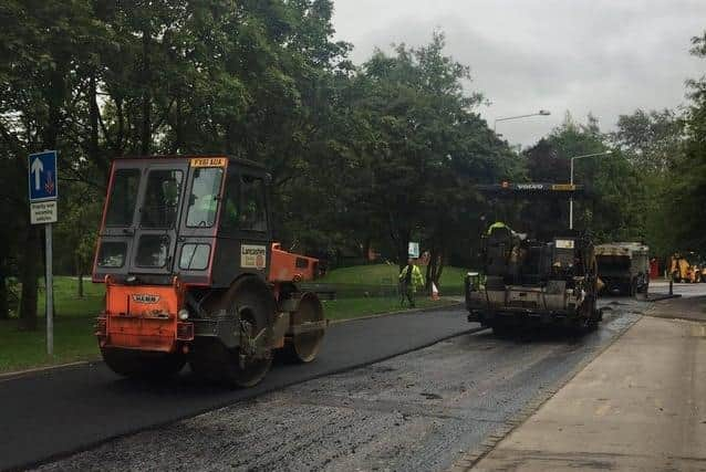
Almost 90 schemes have been identified - amounting to over 100 routes - after the authority’s cabinet approved how it will spend a total of £38.8m in highways maintenance funding.
The total pot also includes work to upgrade and maintain vital infrastructure such as traffic lights, streetlamps and bridges.
Advertisement
Hide AdAdvertisement
Hide AdHowever, the largest single element of the cash, £18m, has been reserved for improving the surfaces on roads of all types - from main A routes through to unclassified rural estate roads.

The overall budget is made up of £28.8m from the annual highways grant to Lancashire County Council from the government, plus an extra £10m pumped into road maintenance by the authority when it set its budget last month. The plans exclude Blackpool and Blackburn with Darwen, where the standalone authorities in those areas are responsible for the roads.
Conservative cabinet member for highways Keith Iddon said that there will be “a whole raft of schemes” taking place over the next twelve months - and that the extra cash from County Hall had “made a lot of things possible that weren't before”.
However, the leader of the Labour opposition group, Azhar Ali, accused the administration of deciding its pothole priorities with one eye on the political loyalties of the areas where roads are set to be repaired.
Advertisement
Hide AdAdvertisement
Hide Ad“You can see the political bias that has been used, rather than methodology - [so as] to put money into those areas where there are Conservative county councillors.
“All this money is welcome in the areas which need it - but there are a lot of areas that are in a worse state that haven’t had a single penny,” said County Cllr Ali, who condemned the fact that no money had been allocated for streets in East Lancashire where the original cobbles were coming through.
However, county council leader Geoff Driver rubbished the suggestion - and said it was a slur on the authority’s non-political highways staff.
“I can assure you that there has been absolutely no political interference in the determination of where these resources are to be spent - that is [done] purely on the basis of the [policy] priorities that arise as a result of the professional assessment of the officers.
Advertisement
Hide AdAdvertisement
Hide Ad“This administration will have spent £318m on highways [since 2017] - and that’s almost half much again as the previous Labour administration spent [during] its four years, “ County Cllr Driver added.
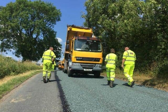
The planned maintenance work will be made up of full-scale traditional resurfacing and also surface dressing - a process of sealing re-laid carriageways to protect them from one of the biggest threats to their condition: water.
One-and-a-half million pounds from the same funding allocation will be spent on preventative “jet patching” - to stop embryonic potholes from deteriorating and forming a wider defect - while £2m will go into footpath repairs.
Separately, the county council agreed during the budget-setting process to invest an additional £2m in walking and cycling routes. Cabinet has now approved a plan to use half of that cash to improve existing routes, with the rest to be reserved for yet-to-be-determined upgrades, including to public rights of way.
Advertisement
Hide AdAdvertisement
Hide AdCabinet members also agreed to use £1.5m of the £5m flood defence funding allocated at the budget specifically for flood alleviation schemes targeting highways, with the remainder reserved for repairing storm damage.
Deputy opposition of the Labour group John Fillis noted that what he described as the “excellent” long-term programme which now dictates road maintenance across Lancashire was established by the party when it was in control of County Hall back in 2014.
Deputy county council leader Keith Iddon acknowledged that, but added: “You did the best you could with the funding you had - unfortunately, it just wasn't enough.”
RESURFACING PLANS
Planned resurfacing and surface dressing work to be carried out during 2021/22, broken down by district, with each entry in the form of: road name(s) - electoral division(s) - exact location of work.
Burnley
Advertisement
Hide AdAdvertisement
Hide AdCrown Point Road, Burnley Rural - from Burnley Road to the cattle grid
Oswald Street, Burnley Central East - full length
Bancroft Road, Burnley North East - whole adopted length from Eastern Avenue junction to outside the Lomax Couplers Limited factory
Harold Street and surrounding area, Burnley Central West, Burnley South West - full Lengths of: Harold Street, Bruce Street, Arran Street, Colin Street, Paisley Street, Girvan Grove, Dunoon Street, Ulster Street, Athol Street South, Prestwich Street, Nairne Street, Prince Street, Netherby Street, Elgin Crescent, Lanark Street, Melrose Avenue, Kinross Street, Airdrie Crescent, Pasturegate Avenue and Pasturegate; Elmwood Street, from Howard Street to Colin Street; Athol Street North, from Howard Street to Colin Street; Coal Clough Lane, from Cog Lane to Melrose Avenue
Chorley
B5247, Station Road, Chorley Rural West - from 17m north of railway bridge wall to the entrance to the railway car park on Station Road
Advertisement
Hide AdAdvertisement
Hide AdA6, Bolton Road, Chorley Central - at junction with Pilling Lane
Babylon Lane, Chorley Rural East - from Chorley Long Lane to Bolton Road
A675 Blackburn Old Road, Hoghton with Wheelton - from Gib Lane to just past the war memorial
Mendip Road, Clayton with Whittle - from Pendle Road to house no. 83
Advertisement
Hide AdAdvertisement
Hide AdPendle Road and surrounding area, Clayton with Whittle - full lengths of Pendle Road and Lancaster Avenue; Mendip Road, from Pendle Road West to the end, including two small offshoots to the south and two small offshoots from Mendip Road, east of Pendle Road
Moody Lane, Chorley Rural West - from Back Lane East south to the gas valve and pond
Bradshaw Lane and surrounding roads, Chorley Rural West, West Lancashire East - Bradshaw Lane, from Ridley Lane to Moody Lane; Dark Lane, from Hall Lane to Ridley Lane; Moody Lane, from Back Lane to Back Lane East; Back Lane East, from Moody Lane to Ridley Lane; Ridley Lane, from Back Lane East to Dark Lane
Fylde
Salwick Road, Fylde East - from Pepper Hill Farm to Harbour Lane
Advertisement
Hide AdAdvertisement
Hide AdCrofts Butts Lane, Fylde South - from Ansboro Avenue to Naze Lane East
Ansbro Avenue estate, Fylde South- full lengths of Ansboro Avenue, Astley Crescent, Further Ends Road and Wyndene Grove; Naze Lane, from Green Lane to Clitheroes Lane; Croft Butts Lane, from Ansboro Avenue to Naze Lane
Hyndburn
A679, Burnley Road, Accrington South, Accrington North - from Eastgate to A56 roundabout
Thwaites Road and surrounding area, Oswaldtwistle, Accrington West and Oswaldtwistle Central - Thwaites Road from the junction with Blackburn Road to outside no.2; plus, the full lengths of Central Avenue, Bedford Close, Dudley Avenue, Cranbrook Avenue, Dorchester Avenue, Radnor Close, Ash Street, Springfield Street and Bent Street
Advertisement
Hide AdAdvertisement
Hide AdThwaites Road and surrounding area, Accrington West, Oswaldtwistle and Oswaldtwistle Central - works on 18 roads: Thwaites Road, from Union Road to proerty no.2 on Thwaites Road; Aspen Lane, from Thwaites Road to Stanhill Lane; Dunster Avenue, from Aspen Lane to the end; Harlech Drive, from Aspen Lane to Stanhill Lane; Barnard Close, from Harlech Drive to Conway Drive; Conway Drive, from Harlech Drive to Stanhill Lane; Banbury Avenue, from Thwaites Road to Harlech Drive; Brecon Avenue, from Radnor Close to Cardigan Avenue; Cardigan Avenue, from Thwaites Road to Harlech Drive; Harvey Street, from Thwaites Road to Union Road; Garden Street, from Harvey Street to the end; Kay Street. from Harvey Street to the end and Simpson Street to the end; Holly Street, from Harvey Street to Cross Street; Cross Street, from Springfield Street to Kay Street; James Street, from Springfield Street to Kay Street; Simpson Street, from Union Road to Springfield Street; St Andrews Close, from Ash Street to the end
Clarke Street, Great Harwood, Rishton and Clayton-le-Moors - full length
Lancaster
A65, Long Level, Lancaster Rural East - from Burr Tree Cottage to the national speed limit signs
Heaton Bottom Road, Heysham - from Lancaster Road to outside Green Hedges property
Advertisement
Hide AdAdvertisement
Hide AdA65, Long Level, Lancaster Rural East - two sections: from Cowan Bridge gateway sign for 256m to the east; and from a point 716m west of the North Yorkshire Boundary for 300m north westerly to the Ireby/Leck Parish boundary
A683, Caton Road, Lancaster Rural East, Lancaster East- from Premier Inn to Lake Enterprise Park
A5105, Marine Road East, Morecambe North - from Broadway to the Golf Club
Collingham Park, Lancaster South East - from Bentham Road to lighting column no.4
Advertisement
Hide AdAdvertisement
Hide AdLune Road, Lancaster Central - from Cedar Road to St Georges Quay, including the junction with St Georges Quay
Fulwood Drive, Morecambe South - two sections: from nos. 45 to 51 and 35 to 41
Sibsey Street, Lancaster Central - from Westbourne Road to Wingate Saul Road
Threshfield Avenue, Heysham - full length
Delamere Avenue, Heysham - full length, including roundabout
Advertisement
Hide AdAdvertisement
Hide AdGrasmere Road, Morecambe North - from Wakefield Avenue to Stuart Avenue
Malvern Avenue, Lancaster South East - full length
Primrose Street, Lancaster East - from Dale Street to house no.42
Balmoral Road, Lancaster East - full length
Sugham Lane, Heysham - from Kingsway to Heysham Road
Merefell Road and surrounding area, Morecambe North - full lengths of Merefell Road, St Nicholas Crescent, The Rise and Ruskin Grove
Pedder Road and surrounding area, Heysham - full lengths of Pedder Road, Pedder Grove, Pedder Avenue and Pedder Drive
Advertisement
Hide AdAdvertisement
Hide AdSunnybank Road and surrounding roads, Morecambe North - full lengths of Sunnybank Road, Wordsworth Avenue, Keats Avenue (two sections), Byron Avenue, Shelley Close, Lowlands Road, Meadow Drive, Chestnut Avenue, Mill Lane, Croftland Gardens, The Green, Orchard Avenue, Hawthorn Road (two sections), St Nicholas Lane, St Margarets Road, and Westfield Drive
Highfield Road and surrounding roads, Lancaster Rural North - full lengths of Highfield Road, Arnhem Road, Alamein Road, Queens Drive, Kings Drive, Prince Avenue, Coniston Road, Ullswater Crescent, Langdale Road, Windermere Road, Ingleborough View and Dunkirk Avenue from Highfield Road to Coniston Road
Ravens Close Road, Lancaster Rural East - from Bentham Road to the boundary
Pendle
A682, Scotland Road, Brierfield and Nelson West - two sections between Texaco Filling Station to Elizabeth Street and Fountain Street to Forest Street
Advertisement
Hide AdAdvertisement
Hide AdA56, Skipton New Road, Pendle Rural - from Rosemere North to Meadow View
Barkerhouse Road, Nelson East - from Leeds Road to Netherfield Road
Meredith Street, Nelson East - from Beaufort Street to Percy Street
Langroyd Road, Pendle Central - from Windsor Street to Red Lane
Advertisement
Hide AdAdvertisement
Hide AdBarnoldswick Road, Pendle Central, Pendle Rural - from Beverley Road to Whitemoor Road and Beverley Road to Gisburn Road
Hill Lane and surrounding area, Pendle Rural - full lengths of Hill Lane, Long Lane and Emmott Lane; Skipton Old Road, from Byron Road to junction of Hill Lane
Sabden Road, Pendle Hill - from Higham Hall Road to outside house no.19 and the adjoining junction of Rake Top Avenue
Noggarth Road, Pendle Hill - from Wheatley Lane Road to Ridge Lane
Preston
Advertisement
Hide AdAdvertisement
Hide AdB5411, Woodplumpton Road, Preston Rural - from house no. 31 before the church, to lighting column 13
B5411, Woodplumpton Road, Preston Rural - from house no. 31 to Tabley Lane
Woods Lane, Preston Rural, Wyre Rural Central - Preston Road to Stavens Pool Bridge
Sharoe Green Lane, Preston Rural, Preston North - from Watling Street Road to Green Drive
Advertisement
Hide AdAdvertisement
Hide AdKings Drive, Preston North, Preston Central West - from Black Bull Lane to the A6
Ribble Valley
A682, Gisburn Road, Ribble Valley North East - from Pendle boundary to Howgill Lane
Main Street, Ribble Valley North East - three sections between Clitheroe Road and Whalley Clitheroe bypass
Rossendale
A671, Market Street, Bacup - from Old Lane to junction of Shanter Close
Advertisement
Hide AdAdvertisement
Hide AdA671, Market Street, Whitworth and Bacup - two sections: from house nos. 397 to 554; and Shanter Close to Oak Street
A682, Burnley Road, Rossendale South, Mid Rossendale - from house no. 41 to the traffic light junction with St Marys Way/Haslingden Old Road/Newchurch Road
A681, Todmorden Road, Rossendale East, Whitworth and Bacup - from junction with St James Square to the Yorkshire boundary
Mercer Crescent, Rossendale West - from Jubilee Road to property no.106
Advertisement
Hide AdAdvertisement
Hide AdCommercial Street, Miles Avenue and Stuart Avenue, Rossendale East - full lengths of each
South Ribble
Station Road, South Ribble West - from Royalty Lane to Chapel Lane
A6, Church Road, South Ribble East - at roundabout junction with Lostock Lane
B6230, Cuerdale Lane, South Ribble East - from Victoria Road roundabout to Vicarage Lane
Advertisement
Hide AdAdvertisement
Hide AdA675, Hoghton Lane, South Ribble East - from Kittlingborne Brow roundabout to Daub Hall Lane
B5257, Brownedge Road, Lostock Hall and Bamber Bridge - from Leyland Lane, Tardy Gate to Todd Lane North
West Lancashire
Gaw Hill Lane, West Lancashire West - from Holly Lane to Liverpool Road
A570, St Helens Road, West Lancashire East - from the Park Road junction to house no. 46, including a section on Ruff Lane from Park Road to Knowsley Road
Advertisement
Hide AdAdvertisement
Hide AdA59, Holborn Hill, West Lancashire West, Ormskirk - from Long Lane to Cottage Lane roundabout
A570, Southport Road, West Lancashire West, Ormskirk - from Harridge Lane to house no. 139
A570, Ormskirk Road, West Lancashire East - from Stanley Gate to just before Scarth Hill Lane
Thornwood and surrounding roads, Skelmersdale West - Thornwood from house nos.1 to 61; Thornberry from lighting column no.4 to the dead end and the bellmouth of Thanet
Advertisement
Hide AdAdvertisement
Hide AdMiddlewood Drive, West Lancashire West - full length from Middlewood Road to the end
Boundary of Meanygate, West Lancashire North - from Johnsons Meanygate track to Fermor Road
Boundary Meanygate, West Lancashire North - from Fermor Road to Hesketh Lane
Moorfield Lane, West Lancashire West - from Smithy Lane to Narrow Moss Lane
Wyre
Advertisement
Hide AdAdvertisement
Hide AdB5270, Sandy Lane, Lancaster Road and Cart Gate, Wyre Rural Central - Sandy Lane from Willow House to Fordstone Avenue. Lancaster Road from the Cart Gate junction to lighting column 114, and Cart Gate from the junction with Lancaster Road to Park Lane
B5268, Fleetwood Road North, Wyre Rural Central - from Wyre West Drive to Rippingdale Way
Dock Street, Fleetwood East - from Victoria Street to Adelaide Street; Albert Street to Warren Street, and a strip in the coach park
B5377, Park Lane, Wyre Rural Central - from Burned House Lane to house no. 231
Advertisement
Hide AdAdvertisement
Hide AdA586, Garstang Road, Wyre Rural Central - from the bridge at the Grapes Pub to lighting column 30 on Allotment Lane
B5268, Fleetwood Road North, Cleveleys East, Cleveleys South and Carleton - from West Drive to Holmes Road
B5270, Sandy Lane, Wyre Rural Central - from Parrox Fold to Fordstone Avenue
Adelaide Street, Fleetwood East - Dock Street to North Albert Street
Advertisement
Hide AdAdvertisement
Hide AdKingsway, Fleetwood West and Cleveleys West - from South Promenade to Bispham Road
Chester Avenue and Ormont Avenue, Fleetwood West and Cleveleys West, Cleveleys South and Carleton Wyre - full lengths of each
Sower Carr Lane, Thornton and Hambleton - from Clay Gap Lane to the A588
County-wide work, as required
Anti-skid and cats eyes renewal
Advanced pre-patching of routes in preparation for surface dressing in 2022/23
Source: Lancashire County Council
Comment Guidelines
National World encourages reader discussion on our stories. User feedback, insights and back-and-forth exchanges add a rich layer of context to reporting. Please review our Community Guidelines before commenting.