Gorge renowned among country’s early geologists


It is to the latter we are going to turn today. I know a number of readers are eager to see new images of the area and, recently, the Briercliffe Society, and Burnley Civic Trust, have been fortunate in that quite a number of new postcards, and photographic images, have come into their possession. I have access to them, so, when something interesting comes up, I will let you know.
This week I am going to introduce you to three new images in that they are new to either, or both, the society or the Trust. I have not got the space to write too much about them, so you will doubtless see them again. In fact, you might remember that, a few weeks ago, I published an image of St John’s Church at Holme Chapel. This is also new, this time to the Briercliffe Society, and its publication was the first time it has been seen in the Burnley Express. I thought I might add this to the three I have chosen for today but I decided that, as the picture had been published only recently, I would not include it. However, I will do so in the not-too-distant future.
Advertisement
Hide AdAdvertisement
Hide AdOf the three pictures I publish today the one of Green’s Clough is the most interesting so far as I am concerned. Those of you who are interested in railways – particularly local railway accidents – may not agree and I suspect that a number of you will be pleased to see the third of the images, that of The Holme. It could be, however, that those who reside in Cliviger might not be too pleased to see that the maker (the famous firm of Friths) thought this lovely building was in Burnley. Of course, it wasn’t, when the picture was taken and, I dare say there are those in Cliviger who would dispute that it is even today!
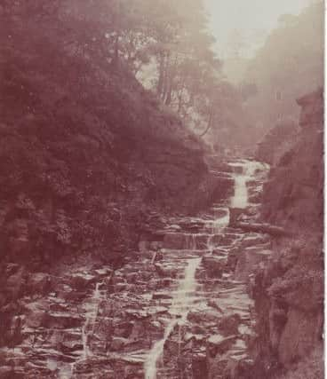
The postcard of Green’s Clough was posted from Burnley on September 11th, 1907. to a Miss P.E. Shoesmith who was on holiday at 10 Eidsforth Terrace, Morecambe. I happen to know who Miss Shoesmith was. She was a member of a Briercliffe family which has had a long connection with Haggate Baptist Church and the cotton mills of Harle Syke.
However, the image is a great one of an almost forgotten, once nationally important, natural feature of the Cliviger Gorge. I have written before that the Cliviger Gorge, in the early 19th Century, was one of the most well known of its kind in the world.
It is not generally recognised that geology is a largely British science. Its early days were in the years of the French Revolutionary and Napoleonic Wars (1793-1815) when British geologists found it difficult to gain access to continental Europe. It would have been all right if one was a member of one of Wellington’s armies but the work of a geologist does not fit in well with the work of the military.
Advertisement
Hide AdAdvertisement
Hide AdRather than travel abroad, and visit the Alps or Pyrenees, pioneer British geologists had to content themselves with the Lake District and Pennines. It was in these places, and others in Britain, that geology was developed as a field of study. Similarly, geomorphology, the study of the physical landscape, was developed in Britain and it is into this category that Green’s Clough falls.
Just to make it clear, geology is the scientific study of the nature, formation, origin and development of the earth’s crust and layers and, of course, this can be profitably studied at Green’s Clough. However, I am going to look at the geomorphology of the area.
The postcard shows a narrow, tree-lined clough with a brook rolling down a rocky river bed. I am not really a geologist, so I hope this description is OK for those of you who have qualifications in the subject. Anyhow, I think you can see what I mean.
You might, just, be able to make out a small group of people at the head of the waterfall. I would love to know who they were. I have had my magnifying glass on them and it appears there is a quite well-dressed young man, on the left. Next to him there is another man, who may be in the clothes of a local farmer. Then there are three of four children, dressed (I think) in Sunday best, and, on the right, it could be that there a number of ladies who have moved and who are, therefore, not as clear as others in the picture.
Advertisement
Hide AdAdvertisement
Hide AdA clough is a steep valley high above what we usually think of as a valley. Often cloughs are tree lined and can contain more than their fair share of ancient woodland. Most dictionaries do not include the word clough because, strictly, it is a dialect word found particularly in Lancashire, Yorkshire and the Lake District. That said, my dialect dictionary “Sounds Gradely”, published by the North-west Sound Archive at Clitheroe, does not include the word either!
It is how the clough was formed that makes it interesting. Cliviger has it streams and one might suppose they have done most to create the landscape, but this is not the case. The most important influence on how Cliviger looks today is the passing through (in fact, the creation of) the Gorge (in other words, the valley) at the end of the last Ice Age.
A combination of glaciers and glacial melt waters, from the west, converged on Cliviger carving out the famous Cliviger Gorge. As the glacial influences carried out their work, they cut off the streams that were already active the area forcing them to fall to the floor of the Gorge from their vantage points high above the new valley bottom.
These streams cascaded off the top of the hills, dropping rapidly to the valley floor. Features of this kind are known as “hanging valleys” and this is what the higher parts of Green’s Clough actually are. This one was famous in its day. Geologists, from all over the country, came to see it and local people acted as guides – sherpas, we might call them – to the gentlemen geologists who visited the area.
Advertisement
Hide AdAdvertisement
Hide AdOf course, the latter were not only coming to see Green’s Clough. The Gorge itself was an attraction as was the fact Cliviger contained not only coal but deposits of iron and lead. A seminal place in the history of geology and geomorphology is Cliviger and this image reminds us of just that.
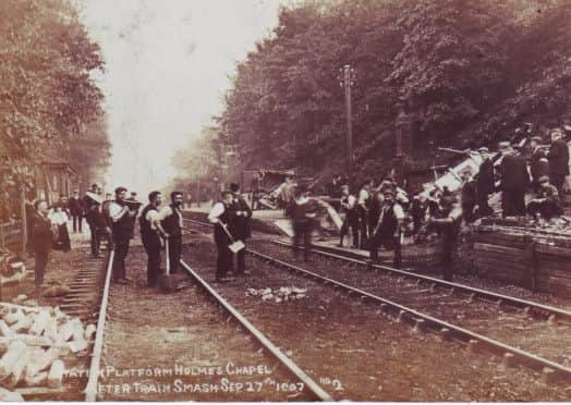
Now let us turn to the Cliviger “train smash” of September 27th, 1907. I do not need to say very much about the incident itself. After all, it is one of the few rail accidents that have taken place in the area. All I will say is that this line, the Burnley to Todmorden line, is one of the potentially most dangerous in the country. It might not rank with some of the railway lines of northern India, or some of the tracks in the Andes of South America, but, in British terms, the gradient on this line is one of the most difficult to negotiate on the British system.
I have heard the line is being considered for electrification and is to become a significant route for passengers and goods. All this is after Dr Beeching closed the line to passengers and almost closed it for everything. He would have done so but the line was needed for the carriage of nuclear fuel to Sellafield.
This card shows the platform at Holme station. The buildings there had been destroyed by the runaway trucks of a locomotive heading in the direction of Todmorden. One man was killed and a great deal of damage was done to the station and area around it.
Advertisement
Hide AdAdvertisement
Hide AdI have not published this image before but the Briercliffe Society has other photos of this incident and at least one of them has seen the light of day in this column. Spend a little time looking at what is going on. We tend to merely cast our eyes over an image such as this without absorbing what is depicted.
The third, and last, image is of the Holme, one of the great houses of Cliviger. It was a fine house before the fire which gutted the building but it is not as old as some would have us believe. The building is actually dated 1603, the year in which Queen Elizabeth I died, but the site of the house is quite a bit older.
Historian Dr T.D. Whitaker is of the family which resided at the Holme and claimed the family were living there in 1431. However, the name is even older, coming from a Norse (Viking) word meaning “island”. The house occupies a slightly higher piece of land, perhaps a little drier and, therefore, when the valley bottom was not properly drained (or drained at all), it would have been here that someone would have chosen to live.
It is a lovely spot. The house enjoyed splendid views from all available vantage points. It is hoped the building can be restored by its present owners.
Advertisement
Hide AdAdvertisement
Hide AdIncidentally, the card was posted on July 25th, 1904. Also, when you visit Cliviger look out for the new Information Boards which have been put up in the parish.
The ones for Holme are to be completed later this year, but more about that nearer the time,